Vernal Fall
Mariposa County, California, United States


Detailed Info
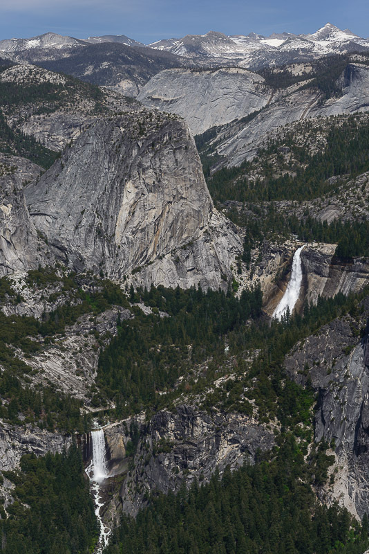
While Vernal Fall isn't displayed quite so prominently in Yosemite Valley as are Bridalveil and Yosemite Falls, Vernal is most certainly among the most popular and frequently visited waterfalls in Yosemite National Park, if not all of California. Accompanied by Nevada Fall, its upstream sibling, the two lofty cataracts are known as The Giant Steps - a title drawing from the very distinct glacially carved cliffs over which the falls plunge almost back-to-back. While Nevada Fall maintains contact with its cliff for the majority of its fall, Vernal Fall is a truly free-falling waterfall and thanks to the large volume of the Merced River it is both the most powerful and broadest free-falling waterfall in California.
Like Nevada, Vernal Fall was first properly examined by USGS surveyor Francois Matthes in or around 1913, at which time he determined the height of the falls to be 317 feet, and that measurement has been assumed to be accurate ever since. However, 1:24,000 scale USGS topographic maps seemed to make it seem like Matthes' figure was a generous overestimate, yet when we surveyed the falls in May of 2013 we measured the falls to stand 309 feet tall. However with large waterfalls such as Vernal where there is heavy mist ejected into the air, the equipment we use for measurements is not entirely reliable. More recently published high resolution topographic models derived from one-meter lidar data however has put the uncertainty to rest; the falls indeed are a bit shorter than Matthes' measurements seemed to suggest, dropping 285 feet rather than 317.
Because of its popularity Vernal Fall is also among the most deadly waterfalls in California. Since 1924 at least 17 people have been swept over the falls after having strayed too close to the river and more may have fallen victim to the river below the falls as well. Most recently in 2011 a group of three crossed the guard rail at the top of the fall to pose for a picture closer to the river, and all three lost their footing, slid into the river and were swept to their death while hundreds of onlookers watched helplessly. When visiting Vernal Fall, please heed all warning signs and stay within the guard rails where provided.
History and Naming
Vernal Fall is the Official name of this waterfall.
Has also been known as:
- Yan-o-pah
According to Lafayette Bunnell the natives of Yosemite Valley called Vernal Fall Yan-o-pah, which means along the lines of "little water cloud". The current name was proposed by Bunnell for the fact that the combination of moss, mist and bright sunlight striking the falls reminded him of Spring, and owes its origins to a poem by Lord Byron.
Our Thoughts
Because of the exposure it receives both inside Yosemite National Park and outside, Vernal Fall is very much a waterfall with a fairly generic reputation. There is little question that it is among the best waterfalls in California and it stands toe-to-toe with many of the best in all of the United States as well, but it personifies the "classic" vision of waterfalls almost so well that once you've seen it, it almost seems like an afterthought (this may just be our highly jaded opinion though). Given that the hike to the falls is not very difficult at all, we recommend that visiting Vernal Fall be an absolute top priority when in Yosemite Valley.
Location & Directions
Coordinates: Unknown Elevation: 5036 feet USGS Map: Half Dome 7 1/2"
Vernal Fall is accessed from the Happy Isles area of Yosemite Valley in Yosemite National Park. From any entrance to Yosemite National Park, proceed to Curry Village at the very end of Yosemite Valley and park. Take the Shuttle Bus to the Happy Isles Nature Center (two stops from Curry Village) and begin hiking on the John Muir Trail, signed for Vernal and Nevada Fall, as well as the summit of Half Dome. Just over three-quarters of a mile the trail crosses the river below the falls, with a fraction of the falls visible from the bridge. Here the trail splits, the Mist Trail climbing alongside the river while the John Muir Trail takes a longer, gentler and drier route up the mountainside. The best views of Vernal Fall are achieved from the Mist Trail, which gets quite intimate with the falls in another quarter of a mile but is considerably steeper, involving a seemingly endless series of stairs cut into the bedrock, constantly pounded by the billowing clouds of spray from the falls. The trails converge just past the top of the falls. As stated before, the falls are dangerous and extreme caution should be exercised around the river above and below the falls. DO NOT under any circumstances cross the guard rails at the top of the falls, do not swim in Emerald Pool just upstream of the falls and do not attempt to get closer to the river to take pictures.
By The Numbers
The information presented in this table is meant to help identify and clarify the physical aspects of the waterfall for comparative purposes. While we try to ensure this information is as accurate as possible, sometimes it will prove necessary to either estimate or flat out guess at certain characteristics where either enough information isn't readily available, is not known, or we were not able to confirm a given trait upon surveying. This information may be changed at any given time to ensure accuracy.
Total Height
The Total Height listed for the waterfall represents the difference in elevation from the top of the uppermost drop, to the bottom of the lowermost drop of the waterfall, including all stretches of interstitial stream in between. Stream between two tiers of a waterfall is counted in its overall height regardless of whether or not that section of the stream would be legitimately considered a waterfall on its own right, were it to be isolated. Waterfalls with only one drop will of have the height of only the single drop listed here.
Tallest Drop
The Tallest Drop figure represents the height of the largest single drop within a multi-stepped waterfall. Waterfalls with only one drop will have the total height of the waterfall repeated here.
Num of Drops
The Number of Drops in a waterfall is a tally of the total number of distinct drops which make up the waterfall. Stretches of interstitial stream in between two or more distinct drops of a single waterfall are NOT considered to be distinct drops of the waterfall unless the section of stream in question would otherwise qualify as a waterfall were it to be isolated.
Avg Width
The Average Width of the waterfall represents the breadth of the waterfall from bank to bank under typical flow conditions, or if the waterfall has been Cataloged, under the conditions which it was most thoroughly surveyed. Often this number will be approximated because of a lack of approachability to many waterfalls. We often utilize Google Earth to measure the width (where imagery is of sufficient quality and resolution to allow it.
Maximum Width
Maximum Width represents a hypothetical measurement of roughly how wide a waterfall could get during peak streamflow or flood conditions. For smaller waterfalls, this figure will generally not differ much from the Average Width measurement, but for broader waterfalls - especially those that feature a crest that isn't constricted - this figure can at times be consideraby larger. Like the Average Width measurement, this measurement will take into account the difference in width at the top and bottom of the waterfall as much as possible, but will often be made based on the width of the crest of th falls alone.
Pitch
The Pitch of a waterfall is an estimated - often very roughly - measure of the average slope or steepness of a waterfall. The Pitch figure only takes into account sections of stream which are actively falling. Pools or stretches of level stream in between two or more successive drops of the falls will not factor in this figure. As an example, a waterfall which features two truly free-falling leaps separated by several dozen yards of flat stream will have a Pitch of 90 degrees. Similarly, a waterfall with two drops separated by a pool, one with a true free-falling drop, and one with a Horsetail type fall will average the two, so while the Plunging drop has a Pitch of 90 degrees, if the Horsetail drop has a Pitch of 45 degrees, the total Pitch will be roughly 67 degrees.
Run
The Run of a waterfall is a measurement representing the total linear distance on the ground between the top and bottom of a waterfall. This figure is not often easy to establish with a high degree of precision and as such will often be estimated. Waterfalls with a longer Run will usually either be less steep, often cascading type waterfalls, or will feature multiple steps separated by shorter stretches of a more gradual gradient streambed.
Form
The system of classification of waterfall forms we use is a heavily modified derivative of the classifications outlined by Greg Plumb in his "Waterfall Lover's Guide to the Pacific Northwest" books. While plumb uses eight distnct forms, we wanted further granularity and opted to break down the hierarchy twofold: first based on the overall pitch of the waterfall, and then based on what shape the fall takes as it makes its descent. There are five primary Categories of falls in this system: Plunge, Horsetail, Steep Cascades, Shallow Cascades, and Rapids. Additional deliniation is then applied depending on characteristics such as the breadth of the falls, whether it splits into two or more channels, whether it falls in multiple successive drops, etc. For more information on our waterfall form classifications, see the Help page.
Watershed
The watershed which a waterfall occurs within, if it is specified, will be based on the ultimate distributary watercourse to the ocean. For example, Washington's Palouse Falls occurs along the Palouse River - which is a tributary to the Snake River, which is itself a tributary to the Columbia River, which ultimately enters the Pacific Ocean, so Palouse Falls would then fall within the Columbia River watershed. Streams which empty directly into the ocean, or into a minor basin which then empties to the ocean will often have this field left blank.
Stream
The name of the watercourse which the waterfall occurs along. If the watercourse is not known to have an officially or colloquially recognized name, this field is left blank.
Avg Volume
The volume of water present in the stream at the location of the waterfall. This is often the most difficult figure to pin down because accurately measuring streamflow is not a simple process. We will rely on USGS data as much as possible, and attempt to take into account seasonal fluctuations in stream levels if possible. There is no guarantee that this figure will be accurate, and in cases where there is no USGS data to use, it may be a very, very rough estimate at best.
Source
If known, the primary source of the watercourse which produces the waterfall will be listed here. This is helpful in determining whether a waterfall may flow more consistently during certain periods of the year - streams which originate in Springs, Lakes, or Glaciers will often flow more consistently throughout the year than those fueled by simply Runoff. The source of the stream may also be either unknown or undetermined.
Flow Consistency
A rough estimation of how many months out of the year the stream which produces the waterfall will actually hold water. The vast majority of waterfalls featured on this website will technically be truly perennial waterfalls (those that flow all year long), but some may see their flow dwindle greatly in the late summer months. This figure will not take into account the winter months when the waterfall may freeze, because in such cases the waterfall will very often be inaccessible. Entries which specify a Flow Consistncy of 12 Months should in general have an acceptable flow at any time of year (but may be better during certain periods - see below).
Best Flow
A general estimate of the best period of the year during which time the falls will be considered at optimal conditions, or flowing at their best. There may be variance within the range specified where the flow will be better or worse, but visiting at any time in the range specified (if available) will generally present the waterfall in its best light.
CloseKey
 |
CatalogedWaterfalls which are Cataloged we have visited and surveyed in person. Statistical information should be quite accurate (for the most part), and exact measurements will often be available (information is not guaranteed to always be up to date). Detailed information, directions, and photographs will almost always be available. |
 |
ConfirmedConfirmed Waterfalls are known to exist, should be relatively accurately mapped and geotagged, and the statistical information available will often be dependable. If height information is presented, it may be estimated but should be accurate. Directions will not likely be available. |
 |
UnconfirmedUnconfirmed Waterfalls are often marked on a published map, but we have yet to confirm the exact location and / or whether or not its stature is significant enough to qualify for listing in the database. Statistical information may be estimated and may be inaccurate. No directions. |
 |
UnknownWaterfalls marked as Unknown are either suspected to exist based on heresay or a hunch, or we have received unverified information suggesting a waterfall may exist near the location provided but cannot corroborate it in any way. Geodata may not be accurate, the location may not be known at all, and statistical information will be estimated and highly inaccurate. |
 |
InundatedInundated Waterfalls have been submerged beneath lakes or reservoirs, usually a result of impoundment of a river behind a dam, and most often no longer functionally exist (there may be rare exceptions). We maintain records for these features out of historical importance. |
 |
SubterraneanThough not common, some waterfalls can be found entirely underground within cave systems. Access to subterranean waterfalls can vary from easy via developed walkways to requiring a high level of extremely technical spelunking skill, including familiarity with ropework and a distinct lack of claustrophobia. |
 |
DisqualifiedWaterfalls which have been marked as Disqualified do not have the necessary stature or features to qualify as a legitimate waterfall according to our criteria. We will maintain records for entries with this status where the feature is well known and / or may have been historically referred to as a waterfall at some point in time. |
 |
PostedPosted Waterfalls are known to exist, and we may have a large amount of information associated with them, but are located on private property and are not legally accessible to the general public. Accessing waterfalls with this status should not be attempted without first being explicitly granted permission of the property owner. |